Showing posts with label Woodland. Show all posts

Sunday, 22 February 2015

Hatfield Forest, Essex (3.5 miles)

Needing to drop our daughter off for an early flight to Rome from Stansted Airport we thought we’d make the most of the early start and explore Hatfield Forest just a few miles away.

Hatfield was once a medieval royal hunting forest now owned by the National Trust.  This large site has numerous possibilities for walks but as it was our first visit I downloaded a 3.5 mile route from the website.   Needless to say despite the instructions and a map we got lost and ended up doubling back and going off track enough to add a further 2 miles to the walk!

Although we visited in February and most of the trees are deciduous and bare it was a cold and frosty morning and the parkland looked beautiful in the early rising sunshine.

Early sunshine at Hatfield Forest

There are lots of deer in the forest and we were lucky enough to see quite a few, although mostly in the trees and they always saw us before we saw them!

Deer at Hatfield Forest

Don’t be put off by the forest’s close proximity to the airport runway.  The planes are only really visible for the first third of the walk and although I noticed the noise initially after about half an hour I forgot about it completely.  It is an interesting contrast of nature and machine when they fly over as you are watching a herd of deer.

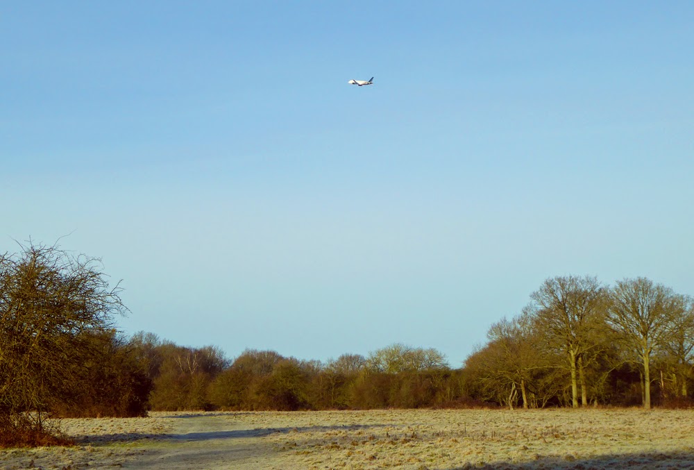
Hatfield Forest is close to Stansted Airport

We parked in the first car park which is free if you are a NT member.  There is another car park further into the forest but as we were early this was not open. According to the website the second car park is often shut if the weather has been wet.

Hatfield Forest

The National Trust website gives the directions for the walk we were intending to do.  We went wrong somewhere around point 5-6 and ended up coming back through Street Coppice and out looking across at point 4 again. We went back the way we came walking straight through the woods and 'rides' until we got to point 7. The forest is kept as natural looking as possible so there are very few markers to help!

Deer in Hatfield Forest

Our route should have been: 3.5 miles
Our route was 5.5 miles
See the route on NT website
Terrain: Mostly flat, grass paths and woodland. Boardwalk and gravel drive in places. Parts can get very muddy in the winter or wet weather. Boots advised! Dogs are allowed but must be kept on a lead if livestock are present.
Habitats: Meadows, grassland, woodland, lake, wetlands
Facilities: Car parking (front car park is 24 hr. Parking is free for NT otherwise chargeable); toilets (24hr), shop and cafe (check website for opening times) near the lake. Pubs in Takeley.

Sunday, 1 February 2015

Whittlesford Village Loop (2 miles)

Whittlesford is my old home village so I know it well.  On this particular day I was intending to take North Road in a northerly direction but as it was a northerly cold wind and had started to sleet I changed my mind and took the walk the other way round.  I have given the directions as I walked below but as is often the case there are lots of small variations on the map.  The walk starts off at the village green (The Lawn), passes the village church, through the village and on into the Millennium Wood before turning back towards the church.

There is parking on The Lawn off of the main road but I started my route from the pavilion on the other side.

1.  With the pavilion on your left take the road on the right passing some bungalows.  When you reach a large tree on your left take the left hand path and go straight ahead bearing right for the church.

St Mary's & St Andrew's Church, Whittlesford, Cambridgeshire

2.  Go through the church yard of St Mary's and St Andrew's and follow the path ahead  For this walk ignore the path on the right, keep going forward passing the cemetery. Follow this wider pathway (known locally as The Baulks) to the gateway at the end.

3.  You are now on the main road - North Road.  It is here that I decided to change direction around the loop so I turned left, followed the path, crossed the road at The Tickell pub and turned right onto the High Street.

4.  Go past the shop and on up the High Street, following the road as it bears round to the right.

5.  Take a turning on your right called Vicarage Lane and walk to the end.  The road becomes a footpath.  Follow this path straight across the field until you come to the edge of the Millennium Wood.

Catkins in Millennium Wood, Whittlesford

6.  There are three possible paths around and through the wood, all link up to each other but I took the middle path through the trees.  Follow this past a bench on your left and bear right. Follow until you come out of the trees with a farm on your left and the main road in front of you.

Millennium Wood, Whittlesford, Cambridgeshire

7.  Cross the road to the path and go right.  Follow the path passing The Bees in the Wall pub, and then the village sign until you come to the end of The Baulks again.

Village Sign, North Rd, Whittlesford

8.  Turn left up The Baulks and continue until you come to a small pathway on your right before reaching the cemetery.  Take this pathway until you come to a gap.  You can either go straight on or turn right and follow the roadway.  Either way you will come out on Church Lane.  Take a left and walk up the road alongside a red brick wall.  When you come to the end go right, then left and you are back at the bungalows and the pavilion is in front of you.

My route was 2 miles
See the route on mapometer.com
Terrain: Flat, tarmac, grass track, gravel through the churchyard.
Habitat: Grass, fields, woodland
Facilities: No public toilets on route. Shop on High Street, pubs - The Tickell and The Bees in the Wall.

Monday, 5 May 2014

Ickworth (South Pleasure Grounds) (4 miles)

Ickworth house and park belongs to the National Trust.  It is free to walk in the extensive grounds.

This route is taken from the website (South Pleasure Grounds walk).  I have copied and pasted their instructions as they were pretty good and added the odd note where I thought helpful.

1. Starting at the Porter's Lodge visitor reception take the path (on the right) towards the Walled Garden (and the church). You will pass a small pond on your right.


St Mary's Church, Ickworth

2. Just past the church, go straight ahead by turning off the hard road onto the grass path that leads
to the left of the Walled Garden. Go through the five bar gate and immediately bear left on the grass
path veering away from the brick wall. Within a couple of minutes you'll see our bird hide on your right.

3. Continue along this path past the bird hide (do not take the right fork when you come to it, just carry on), cross over the wooden foot bridge (and walk along wooden walkway) and take the right
hand fork in the path, climbing a short series of steps bringing you to the Fairy Lake.


Fairy Lake, Ickworth

4. Turn right at the Fairy Lake and continue along the footpath (pass The Round House) and take the second right turn marked Katharine's Wood.

5. In Katharine's Wood continue to the end of this path until you reach a cottage called Ivy Cottage.
Turn right at the cottage and follow this path until you get to the beginning of Lownde Wood. (Pause here to take in the view of the estate and the Rotunda)


Views of the park and rotunda

6. Enter Lownde Wood on the patch (the middle path) between the Lownde Wood and red footpath way marker.

7. In Lownde Wood follow the path which firstly bears right and then bears left. (Keep going!) On your left you will pass an observation post before coming to a clearing break. Cross over the clearing (keep the observation post on your left shoulder do not turn right - the path isn't well used or marked) and enter to wood again. On your right hand side you will come to a metal fence, continue on the path to a Y junction and take the right grassy footpath.

8. At the crossroads turn left and you will cross a small wooden bridge. Follow the dirt track which will
lead you to a small brick bridge at the corner of the field. Keep following the path, passing a rusty,
corrugated and ruined metal cabin on your right.

9. At the next junction turn right and follow the path until you reach a T junction where you'll see an
observation post. Turn right and go through the gate into the field.

10. As soon as you're through the gate turn right and follow the wood line for a short time keeping it to
your right, until you can see the Rotunda in the distance ahead of you.

11. Leave the wood line and head across the field towards the Rotunda passing laid down tree trunks
and passing through a gate on your way. You're heading for a kissing gate (in the distance at the bottom right hand corner of the field) which is lined up with the centre of the Walled Garden just beyond it.

12. Go through the kissing gate and turn left. Walk by the side of the Canal Lake and cross over the
decorative (wooden) foot bridge at the end of the lake.

13. Having crossed the foot bridge, keep the Walled Garden to your right and continue up the slope
to the hardened footpath. Turn right and retrace your steps on this path past the Church and back
towards your start point.

Our route was 3.9 miles
See the route on mapometer.com
Terrain: Flat, grass and dirt tracks mostly, moderate climb at the end. Latch gates, kissing gate, some steps.  Can be muddy in places in wet weather.
Habitats: Meadows, fields (animals grazing), woodland, lakes.
Facilities: Toilets and cafe at Porter's Lodge entrance and at the Rotunda. Rotunda toilets can also be accessed at the back.  Toilets also near the church.

Thursday, 29 August 2013

Holkham & Wells Circular, Norfolk (4.6 miles)


Holkham is a village on the north Norfolk coast and has a magnificent beach stretching for miles.  This walk takes in the beach east to Wells-next-the-Sea and returns back through pine woods.  The walk is part of the Norfolk Coastal Path which stretches from Hunstanton to Cromer.  The walk can be undertaken in many stages and is shadowed by the Coasthopper bus service so you can always walk and bus back if you want to go further.

Holkam is also home to Holkham Hall and Estate which we also visited briefly.  If you pay for the day when parking near the beach this can be used in the park also.  Check website for opening times and other prices.

We were lucky when we visited the beach as the tide was low.  Having seen the tide line I would recommend checking the tide times and walking at low tide to appreciate the beach at its best.

Parking is available in Lady Anne’s Drive, opposite The Victoria, in Holkham.


Holkham beach


After parking go through the gates and follow the pathway in front to the beach viewing area.  Take the boardwalk to the right until you reach a bench.  Go down the boardwalk onto the beach basin.

Walk straight ahead and turn right in front of the sand dunes.  The sand on Holkham beach is beautifully soft but for ease of walking we prefer to go right down to the shore line - obviously how far this will be will depend on the tide.

Follow the beach for about 2 miles until you see the beach huts of Wells on your right.  If the tide allows, walk in front of the small dunes headland and then turn up the beach following the boat channel which will then be on your left.  


Beach huts at Wells-next-the-Sea


At the top of the beach head for the boardwalk under the lifeguard and go up the sloped roadway.  Once at the top of the slope you will see Wells harbour and the long straight pathway that runs alongside and heads to the town in the distance.  

If you aren’t detouring to visit the town, take a right down the steps, stopping at The Beach Cafe for refreshments if you wish (toilets are opposite the cafe).  For the return journey take the path that runs alongside the righthand side of the car park.  Go through the gateway and take the left track into the nature reserve.

Follow the wide sandy track along the edge of the pinewoods for about a mile and a half until you reach Lady Anne’s Drive again.


Wells harbour looking towards the town

Our route was: 4.55 miles
See the route on mapometer.com
Terrain: mostly flat, sand, sandy paths,
Habitat: beach, dunes, pine woods
Facilities: Toilets and beach cafe at Wells.  Further toilets and Stables cafe at Holkham Estate (parking charges apply if not included in your beach parking).  Note:  Good to see gluten free options available in both cafes

Friday, 16 August 2013

Anglesey Abbey, Cambridgeshire (2.5 miles)


Anglesey Abbey is a National Trust property near Lode in Cambridgeshire.  As well as the house and mill, there are extensive gardens, walks, a woodland discovery trail, hide, meadows, a river and a pond.  It is famous for snow drops in the early Spring and can get extremely busy at that time and during specific events over the school holiday period.  Parking is free but there is an entrance cost if you are not a NT member.  

There are many ways to wander around the gardens and parkland of Anglesey Abbey but the route we often take goes around the edge and takes in a little of all the habitats.  


Anglesey Abbey

Once through the visitors centre entrance go straight on, turn right and then take a small path on your left.  Follow this path through a small woodland area until you come to the end and bear right.  

Go over the avenue of trees and through a small gateway.  Follow the path to the left again until you reach the end.  Cross over again and bear right slightly until you reach the entrance to the wildlife discovery area.  

Go over the small bridge and stay left, walk past the tree house and through the pathway lined with logs.  Keep going into the wood and when given an option stay left until you end up going around the back of the wood and start to return down the other side.  Take a quick detour here to your right to visit the hide but be sure to return to the same pathway.  Continue along until you reach the end of the discovery trail, past the sightings blackboard and over another bridge.  

Turn left and follow the track down back towards the house.  Go past the house and croquet lawn and turn left down the side of the house.  Go straight across and follow this pathway through a gateway.  Follow the path as it winds its way towards the river.  Go right along the river towards the mill.  


Autumn in the Anglesey Abbey gardens

Turn right at the mill and follow the pathway.  Keep following the path through the silver birch garden and carry on through gardens until it brings you back out at the visitor centre.

Our route was: 2.47 miles
See the route on mapometer.com
Terrain: Flat, mixture of gravel paths, grass and bare paths
Habitat: Gardens, meadows, river, woodland
Facilities: Free parking. Toilets, shop and restaurant in the visitor centre, toilets by the house, Eco-toilet in the discovery woodland section.
Why not have a look at my other photos from Anglesey Abbey and also those from their winter lights display